Difficulty
K3
Difficult via ferrata
Location TBC
Aletsch Klettersteig is a K3 via ferrata in Location TBC.
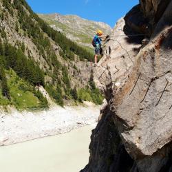
Image: Source: ferrataguide:1035
Difficulty
K3
Difficult via ferrata
Current status
Currently reported open
Checked 17 h ago
Total time
3 h 30 min
Approach + via ferrata + descent
Last lift down
Check Location TBC timetable
Segment timings and vertical stats from the current VFOS dataset.
The via ferrata starts directly next to the parking, above the concrete barrier. Well secured, descend through a channel towards the water and then walk on natural and (very many) artificial steps, with your left hand on the taut iron rope, up valley. With a little luck, you can see ferrata climbers already on the other side of the lake. Eventually, the highlight of the route, the large suspension bridge, comes into view. After the airy crossing high above the water head back along the east bank. This second section of the Ferrata is a bit more challenging, but also more varied. You have to grasp vigorously to the steep rocks of the canyon; this is followed by a few very funny, slightly strenuous crossings (including wooden beams), depending on the water level with different amounts of air under the soles of the shoes. The route finishes back at the Gibidum dam.
No escape point details are recorded yet.
Zoomable topographic map showing available approach, via ferrata, descent, start, finish, and parking geometry. The Download GPX link near the route map heading provides the same route geometry as a file.
Plan around the trailhead, parking, and public transport links.
Last lift down
Check operator
Transport nodes are not linked yet. Use the start-point navigation and verify access locally.
VFOS editorial ratings on a 1-5 scale.
Variety
How much the route changes in movement and terrain.
TBC TBC
Complexity
Route-finding and technical problem-solving beyond pure grade.
TBC TBC
Beauty
Scenery, setting, and overall aesthetic quality.
TBC TBC
Exposure
Airiness and exposure independent of technical difficulty.
TBC TBC
Sustained effort
How continuous or relentless the physical effort feels.
TBC TBC
No crux tags are recorded yet.
Aletsch Klettersteig is a K3 via ferrata in Location TBC.
Check current local information before setting off.
In Switzerland, call Rega on 1414 for mountain rescue. European emergency number: 112.
Cell coverage can be patchy in gorges, valleys, and behind ridges. Download route notes and tell someone your plan.
Avoid thunderstorms and wet rock. Via ferrata cables can become hazardous quickly in poor weather.
https://ferrataguide.com/ferrata/Aletsch_Klettersteig
Last scraped: 4 Jun 2026 · Source used for attribution and factual cross-checking; canonical VFOS text is paraphrased separately.
https://www.sac-cas.ch/en/huts-and-tours/sac-route-portal/gibidum-reservoir-7784/via-ferrata/aletsch-via-ferrata-695/
Last scraped: 21 Jun 2026 · Facts harvested from public source pages; VFOS stores extracted facts and links back to source.
https://www.openstreetmap.org/way/1012204581
Last scraped: 4 Jun 2026 · OpenStreetMap object reference used for coordinate/source provenance; data available under ODbL.
https://www.openstreetmap.org/way/1012204582
Last scraped: 4 Jun 2026 · OpenStreetMap object reference used for coordinate/source provenance; data available under ODbL.
https://www.openstreetmap.org/way/1012204583
Last scraped: 4 Jun 2026 · OpenStreetMap object reference used for coordinate/source provenance; data available under ODbL.
https://www.openstreetmap.org/way/1012204584
Last scraped: 4 Jun 2026 · OpenStreetMap object reference used for coordinate/source provenance; data available under ODbL.
https://www.openstreetmap.org/way/184129357
Last scraped: 4 Jun 2026 · OpenStreetMap object reference used for coordinate/source provenance; data available under ODbL.
https://www.openstreetmap.org/way/69416992
Last scraped: 4 Jun 2026 · OpenStreetMap object reference used for coordinate/source provenance; data available under ODbL.
https://www.openstreetmap.org/way/69416994
Last scraped: 4 Jun 2026 · OpenStreetMap object reference used for coordinate/source provenance; data available under ODbL.
No contested fields are currently flagged.
Weather