Difficulty
K4
Very difficult via ferrata
Kandersteg, BE
A popular Kandersteg route to Allmenalp, seeded to prove harder-route filtering, transport notes, and status tracking from a dedicated local source.
Image: Source: website
Difficulty
K4
Very difficult via ferrata
Current status
No reliable current status yet
Checked 17 h ago
Total time
4 h 20 min
Approach + via ferrata + descent
Last lift down
Check Luftseilbahn Kandersteg-Allmenalp timetable
Segment timings and vertical stats from the current VFOS dataset.
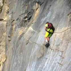
Climb a 100-metre-high wall, keeping to the left. The long traverse brings to mind the famous Hinterstoisser traverse on the Eiger north face. Cross the Allmibach on a Nepali style three-rope bridge. A grassy slope leads up to the Swiss flag and route book below a 10 m overhanging roof. This is then overcome with the help of a unique ladder which is twisted 180 degrees. To the left of the waterfall climb up to a ridge behind which the Allmibach flows. Facilitated by ladders, the crux, a long traverse up to the right and around a corner, requires strong arms. A second three-rope bridge (more courageous via ferrata climbers can take the 40-metre long zip-line further up; pulley and brake/retrieving rope available) crosses the Allmibach once more. The last of the group must slow down himself using his gloved hands on the supporting rope or take the bridge. Finally, climb up a partly vertical face to the exit at ca. 1600 m (3 h 10 min). In 20 minutes, hike to Undere Allme (1723 m) to reach the top station of the cableway and the restaurant.
No escape point details are recorded yet.
Zoomable topographic map showing available approach, via ferrata, descent, start, finish, and parking geometry. The Download GPX link near the route map heading provides the same route geometry as a file.
Plan around the trailhead, parking, and public transport links.
Last lift down
Check operator
VFOS editorial ratings on a 1-5 scale.
Variety
How much the route changes in movement and terrain.
Very high 5/5
Complexity
Route-finding and technical problem-solving beyond pure grade.
High 4/5
Beauty
Scenery, setting, and overall aesthetic quality.
Very high 5/5
Exposure
Airiness and exposure independent of technical difficulty.
Very high 5/5
Sustained effort
How continuous or relentless the physical effort feels.
High 4/5
No crux tags are recorded yet.
A popular Kandersteg route to Allmenalp, seeded to prove harder-route filtering, transport notes, and status tracking from a dedicated local source.
Check current local information before setting off.
In Switzerland, call Rega on 1414 for mountain rescue. European emergency number: 112.
Cell coverage can be patchy in gorges, valleys, and behind ridges. Download route notes and tell someone your plan.
This route is flagged as exposed or high-grade; avoid thunderstorms, wet cables, and fast-changing alpine weather.
https://www.allmenalp.ch/en/experience/climbing.html
Last scraped: 30 May 2026 · Source used for attribution and factual cross-checking; VFOS stores only short, paraphrased seed notes.
https://ferrataguide.com/ferrata/Klettersteig_Kandersteg_-_Allmenalp
Last scraped: 4 Jun 2026 · Source used for attribution and factual cross-checking; canonical VFOS text is paraphrased separately.
https://www.openstreetmap.org/relation/9385137
Last scraped: 30 May 2026 · OpenStreetMap object reference used for seed coordinate provenance; data available under ODbL.
https://www.sac-cas.ch/en/huts-and-tours/sac-route-portal/allmenalp-8207/via-ferrata/via-ferrata-kandersteg-allmenalp-1840/
Last scraped: 5 Jun 2026 · SAC-CAS route portal source used for route geometry and factual cross-checking; VFOS links back for attribution.
https://www.openstreetmap.org/way/1323417858
Last scraped: 4 Jun 2026 · OpenStreetMap object reference used for coordinate/source provenance; data available under ODbL.
https://www.openstreetmap.org/way/1442538805
Last scraped: 4 Jun 2026 · OpenStreetMap object reference used for coordinate/source provenance; data available under ODbL.
https://www.openstreetmap.org/way/1455075841
Last scraped: 4 Jun 2026 · OpenStreetMap object reference used for coordinate/source provenance; data available under ODbL.
https://www.openstreetmap.org/way/307363411
Last scraped: 4 Jun 2026 · OpenStreetMap object reference used for coordinate/source provenance; data available under ODbL.
https://www.openstreetmap.org/way/612254146
Last scraped: 4 Jun 2026 · OpenStreetMap object reference used for coordinate/source provenance; data available under ODbL.
https://www.openstreetmap.org/way/612254147
Last scraped: 4 Jun 2026 · OpenStreetMap object reference used for coordinate/source provenance; data available under ODbL.
https://www.openstreetmap.org/way/612254148
Last scraped: 4 Jun 2026 · OpenStreetMap object reference used for coordinate/source provenance; data available under ODbL.
https://www.openstreetmap.org/way/612254149
Last scraped: 4 Jun 2026 · OpenStreetMap object reference used for coordinate/source provenance; data available under ODbL.
https://www.openstreetmap.org/way/612254150
Last scraped: 4 Jun 2026 · OpenStreetMap object reference used for coordinate/source provenance; data available under ODbL.
https://www.openstreetmap.org/way/612254151
Last scraped: 4 Jun 2026 · OpenStreetMap object reference used for coordinate/source provenance; data available under ODbL.
https://www.openstreetmap.org/way/612254153
Last scraped: 4 Jun 2026 · OpenStreetMap object reference used for coordinate/source provenance; data available under ODbL.
https://www.openstreetmap.org/way/612254154
Last scraped: 4 Jun 2026 · OpenStreetMap object reference used for coordinate/source provenance; data available under ODbL.
https://www.openstreetmap.org/way/612254155
Last scraped: 4 Jun 2026 · OpenStreetMap object reference used for coordinate/source provenance; data available under ODbL.
https://www.openstreetmap.org/way/612254156
Last scraped: 4 Jun 2026 · OpenStreetMap object reference used for coordinate/source provenance; data available under ODbL.
https://www.openstreetmap.org/way/612254157
Last scraped: 4 Jun 2026 · OpenStreetMap object reference used for coordinate/source provenance; data available under ODbL.
https://www.openstreetmap.org/way/612254158
Last scraped: 4 Jun 2026 · OpenStreetMap object reference used for coordinate/source provenance; data available under ODbL.
https://www.openstreetmap.org/way/612254159
Last scraped: 4 Jun 2026 · OpenStreetMap object reference used for coordinate/source provenance; data available under ODbL.
https://www.openstreetmap.org/way/612254160
Last scraped: 4 Jun 2026 · OpenStreetMap object reference used for coordinate/source provenance; data available under ODbL.
Weather