Difficulty
K2
Moderate via ferrata
Berner Alps
Chäligang, Engstligenalp Adelboden is a K2 via ferrata in Berner Alps.
Image: Source: ferrataguide:621
Difficulty
K2
Moderate via ferrata
Current status
No reliable current status yet
Checked 17 h ago
Total time
2 h 30 min
Approach + via ferrata + descent
Last lift down
Check Berner Alps timetable
Segment timings and vertical stats from the current VFOS dataset.
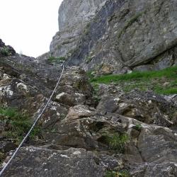
This rocky ramp is the so-called Chaligang. Previously fitted with scraps of bolt and chain, with the odd step mashed into the rock, it is now a fully fledged iron staircase. Today you can secure yourself via trusty looking cables, and make use of some extra iron rungs. As you approach the wall, it appears to grow before your eyes. After a steep slog, the cable-secured path strikes out across the wall and leads into a cauldron above the lower Engstligenfalls (good rest/ bivouac sight). Above a wooden bench with a "visitor book", the ferrata turns right, leading towards a ridge via a grassy, rubble filled gully. It continues to traverse, still further right, and finally climbs up onto the mountain track which leads round to the south of P. 1810, near the upper Engstligenfall. Descend from here, or continue upslope on the normal hiking path past three alp huts, to cross a small bridge over the Engstligen and reach Engstligenalp (1965 m, 2½ hours).
From the top of the via ferrata, ca. 1800 m, either ascend to the top station, or descend on foot via the obvious mountain path.
No escape point details are recorded yet.
Zoomable topographic map showing available approach, via ferrata, descent, start, finish, and parking geometry. The Download GPX link near the route map heading provides the same route geometry as a file.
Plan around the trailhead, parking, and public transport links.
Last lift down
Check operator
VFOS editorial ratings on a 1-5 scale.
Variety
How much the route changes in movement and terrain.
TBC TBC
Complexity
Route-finding and technical problem-solving beyond pure grade.
TBC TBC
Beauty
Scenery, setting, and overall aesthetic quality.
TBC TBC
Exposure
Airiness and exposure independent of technical difficulty.
TBC TBC
Sustained effort
How continuous or relentless the physical effort feels.
TBC TBC
No crux tags are recorded yet.
Chäligang, Engstligenalp Adelboden is a K2 via ferrata in Berner Alps.
Check current local information before setting off.
In Switzerland, call Rega on 1414 for mountain rescue. European emergency number: 112.
Cell coverage can be patchy in gorges, valleys, and behind ridges. Download route notes and tell someone your plan.
Avoid thunderstorms and wet rock. Via ferrata cables can become hazardous quickly in poor weather.
https://ferrataguide.com/ferrata/Ch%C3%A4ligang%2C_Engstligenalp_Adelboden
Last scraped: 4 Jun 2026 · Source used for attribution and factual cross-checking; canonical VFOS text is paraphrased separately.
https://www.sac-cas.ch/en/huts-and-tours/sac-route-portal/engstligenalp-8208/via-ferrata/chaeligang-via-ferrata-1839/
Last scraped: 21 Jun 2026 · Facts harvested from public source pages; VFOS stores extracted facts and links back to source.
No contested fields are currently flagged.
Weather