Difficulty
K3
Difficult via ferrata
Berner Alpen
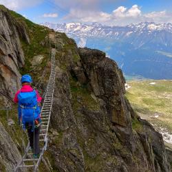
Eggishorn - Klettersteig is a K3 via ferrata in Berner Alpen.
Image: Source: ferrataguide:381
Difficulty
K3
Difficult via ferrata
Current status
Currently reported open
Checked 17 h ago
Total time
2 h
Approach + via ferrata + descent
Last lift down
Check Berner Alpen timetable
Segment timings and vertical stats from the current VFOS dataset.
A narrow track leads gently downhill, eastwards over the rocky grass slope of the Fiescherhorli's SE flank. Soon, the first safety cables appear; shortly after you are confronted with the 20-meter-long suspension bridge, a somewhat shaky construction. Beyond that, the route continues across the 'Snowfield Traverse', after which a short ascent leads to the ca. 40-metre-long three-cable bridge. If you get weak knees, you can avoid this particularly breezy challenge. From "Gemstritt", the route continues to the foot of the "wall creeper slabs" (emergency exit, approx. 2700 m). Here the goes (finally!) upwards, first almost vertically up a long row of iron rungs. After an airy traverse and a few small ups and downs, the "Adlerspitz" presents several small towers. The route follows these in stimulating, undulating terrain; the last (mini) challenge consists of another small suspension bridge, after which you climb scree to reach the cable car station (2869 m, 2 hours).
No escape point details are recorded yet.
Zoomable topographic map showing available approach, via ferrata, descent, start, finish, and parking geometry. The Download GPX link near the route map heading provides the same route geometry as a file.
Plan around the trailhead, parking, and public transport links.
Last lift down
Check operator
VFOS editorial ratings on a 1-5 scale.
Variety
How much the route changes in movement and terrain.
TBC TBC
Complexity
Route-finding and technical problem-solving beyond pure grade.
TBC TBC
Beauty
Scenery, setting, and overall aesthetic quality.
TBC TBC
Exposure
Airiness and exposure independent of technical difficulty.
TBC TBC
Sustained effort
How continuous or relentless the physical effort feels.
TBC TBC
No crux tags are recorded yet.
Eggishorn - Klettersteig is a K3 via ferrata in Berner Alpen.
Check current local information before setting off.
In Switzerland, call Rega on 1414 for mountain rescue. European emergency number: 112.
Cell coverage can be patchy in gorges, valleys, and behind ridges. Download route notes and tell someone your plan.
Avoid thunderstorms and wet rock. Via ferrata cables can become hazardous quickly in poor weather.
https://ferrataguide.com/ferrata/Eggishorn_-_Klettersteig
Last scraped: 4 Jun 2026 · Source used for attribution and factual cross-checking; canonical VFOS text is paraphrased separately.
https://www.sac-cas.ch/en/huts-and-tours/sac-route-portal/eggishorn-548/via-ferrata/eggishorn-via-ferrata-666/
Last scraped: 21 Jun 2026 · Facts harvested from public source pages; VFOS stores extracted facts and links back to source.
https://www.openstreetmap.org/way/430739017
Last scraped: 4 Jun 2026 · OpenStreetMap object reference used for coordinate/source provenance; data available under ODbL.
No contested fields are currently flagged.
Weather