Difficulty
K4
Very difficult via ferrata
Location TBC
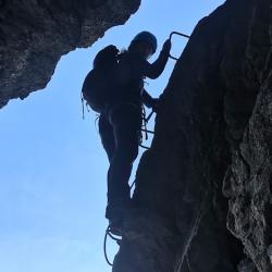
Eiger Ostegghütte is a K4 via ferrata in Location TBC.
Image: Source: ferrataguide:1977
Difficulty
K4
Very difficult via ferrata
Current status
No reliable current status yet
Checked 17 h ago
Total time
4 h 45 min
Approach + via ferrata + descent
Last lift down
Check Location TBC timetable
Segment timings and vertical stats from the current VFOS dataset.
From the station Alpiglen (1616 m) follow the Eiger Trail to the junction at P. 1758 where the path to Bonera and Grindelwald splits off. Along this down to a brook (bridge, 1734 m), then more or less horizontal to the turnoff (ca. 1750 m) for Eiger Ostegghütte (¾ hours).
There is no steel cable on the first steep rock step! You must be able to free climb on easy terrain. Afterwards the route ascends safely through a gully, with three steep steps: The second is vertical, the third slightly overhanging on the left side of a chimney. More brittle terrain follows before the land starts to level out and a path eventually leads you left to the Ostegghütte, which is located on a wonderful grassy terrace at 2317 m (3 hours). If you wish to peer into the valley of the Lower Grindelwald glacier, you can also teeter along a path eastwards to a pulpit in the north ridge of the Ostegg. Incredible vantage point for watching the alpenglow light up the Schreckhorn mountain chain.
No escape point details are recorded yet.
Zoomable topographic map showing available approach, via ferrata, descent, start, finish, and parking geometry. The Download GPX link near the route map heading provides the same route geometry as a file.
Plan around the trailhead, parking, and public transport links.
Last lift down
Check operator
VFOS editorial ratings on a 1-5 scale.
Variety
How much the route changes in movement and terrain.
TBC TBC
Complexity
Route-finding and technical problem-solving beyond pure grade.
TBC TBC
Beauty
Scenery, setting, and overall aesthetic quality.
TBC TBC
Exposure
Airiness and exposure independent of technical difficulty.
TBC TBC
Sustained effort
How continuous or relentless the physical effort feels.
TBC TBC
No crux tags are recorded yet.
Eiger Ostegghütte is a K4 via ferrata in Location TBC.
Check current local information before setting off.
In Switzerland, call Rega on 1414 for mountain rescue. European emergency number: 112.
Cell coverage can be patchy in gorges, valleys, and behind ridges. Download route notes and tell someone your plan.
This route is flagged as exposed or high-grade; avoid thunderstorms, wet cables, and fast-changing alpine weather.
https://ferrataguide.com/ferrata/Eiger_Osteggh%C3%BCtte
Last scraped: 4 Jun 2026 · Source used for attribution and factual cross-checking; canonical VFOS text is paraphrased separately.
https://www.sac-cas.ch/de/huetten-und-touren/sac-tourenportal/ostegghuette-2147000085/klettersteig/klettersteig-eiger-ostegg-672/
Last scraped: 21 Jun 2026 · Facts harvested from public source pages; VFOS stores extracted facts and links back to source.
No contested fields are currently flagged.
Weather