Difficulty
K4-K5
Extremely difficult via ferrata
Location TBC
Via ferrata d’Evolène is a K4-K5 via ferrata in Location TBC.
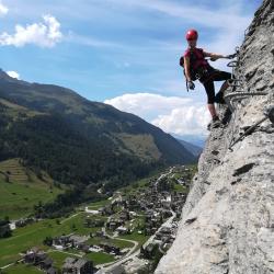
Image: Source: ferrataguide:1054
Difficulty
K4-K5
Extremely difficult via ferrata
Current status
Currently reported open
Checked 17 h ago
Total time
TBC
Approach + via ferrata + descent
Last lift down
Check Location TBC timetable
Segment timings and vertical stats from the current VFOS dataset.
The first sector is called Mur du Grand Duc. This wall is overcome via various vertical, sometimes slightly overhanging passages, between which are traverse ledges. Finally, a long, diagonal climb leads leftward to an airy ladder section before the grass band is reached, the Vire des Chamois. It is possible to exit to the right (south) here. Alternatively, the via ferrata continues northwards along this grass band: first down a bit, then up a long way to the point where you have to down climb on rock to reach a traverse across a vertical wall. Shortly thereafter you are at the foot (about 1610 m) of the Grand Mur. Here is another possible exit, which does not look very inviting. The way forward looks also uninviting but you've got this far ... have courage: the next bit, up under the overhang is not that bad. Then the rock begins to tilt outwards - and the body with it; The carabiners can be weighted in this position, but the crook of the arm works well too. Now it really gets interesting, and there is only one thing to do: keep grabbing the next iron bar, and pull yourself up, up, up. Use your legs, making sure your shoes don't slip. And soon the crux will be over. The rest of the ascent through the Great Wall will seem a 'walk in the park' - until one last surprise: a fragile step, covered in wire netting, which you must more or less elegantly shuffle over. Where the via ferrata ends at ca. 1680 meters, the "Sortie des héros" (exit of heroes) board hangs. From here a path descends through sparse larch forest to a lookout point (about 1660 m) with a bench and route book.
No escape point details are recorded yet.
Zoomable topographic map showing available approach, via ferrata, descent, start, finish, and parking geometry. The Download GPX link near the route map heading provides the same route geometry as a file.
Plan around the trailhead, parking, and public transport links.
Last lift down
Check operator
Transport nodes are not linked yet. Use the start-point navigation and verify access locally.
VFOS editorial ratings on a 1-5 scale.
Variety
How much the route changes in movement and terrain.
TBC TBC
Complexity
Route-finding and technical problem-solving beyond pure grade.
TBC TBC
Beauty
Scenery, setting, and overall aesthetic quality.
TBC TBC
Exposure
Airiness and exposure independent of technical difficulty.
TBC TBC
Sustained effort
How continuous or relentless the physical effort feels.
TBC TBC
No crux tags are recorded yet.
Via ferrata d’Evolène is a K4-K5 via ferrata in Location TBC.
Check current local information before setting off.
In Switzerland, call Rega on 1414 for mountain rescue. European emergency number: 112.
Cell coverage can be patchy in gorges, valleys, and behind ridges. Download route notes and tell someone your plan.
This route is flagged as exposed or high-grade; avoid thunderstorms, wet cables, and fast-changing alpine weather.
https://ferrataguide.com/ferrata/Ferrata_d%E2%80%99_Evol%C3%A8ne_Region
Last scraped: 4 Jun 2026 · Source used for attribution and factual cross-checking; canonical VFOS text is paraphrased separately.
https://www.sac-cas.ch/en/huts-and-tours/sac-route-portal/rocs-de-villa-7802/via-ferrata/via-ferrata-d-evolene-1829/
Last scraped: 5 Jun 2026 · SAC-CAS route portal source used for route geometry and factual cross-checking; VFOS links back for attribution.
No contested fields are currently flagged.
Weather