Difficulty
K5
Extremely difficult via ferrata
Bornes-Alpen
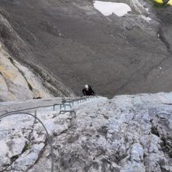
Ferrata de la Tête aux Chamois is a K5 via ferrata in Bornes-Alpen.
Image: Source: ferrataguide:375
Difficulty
K5
Extremely difficult via ferrata
Current status
Currently reported open
Checked 17 h ago
Total time
3 h
Approach + via ferrata + descent
Last lift down
Check Bornes-Alpen timetable
Segment timings and vertical stats from the current VFOS dataset.
A grass band, which gradually becomes just barely a foot of rock, leads out into the north face of the Gämskopf. The depth increases; An initial test for the biceps and nerves is a slight overhang that you have to master in descent. Anyone who gets into trouble here can, after a small cave, extricate themselves prematurely (sign for "échappatoire"). The continuation of the route initially leads upwards, with a second slightly overhanging passage, then alternates from horizontal to vertical leftwards, with almost continuous (maximum) exposure. After a section which is harder for small people, a 5-meter long wooden beam leads over the abyss. Another two small overhangs, and the "ferratisti" finds themselves beside a huge vertical wall, the "Yellow Rock" or Rocher Jaune: and must traverse over bottomless depths, felt with every step. With an increased pulse rate, you can then relax a little on a (comparatively) comfortable ledge. You get the picture: up, left, up left, up left ... until a final, rather sparingly secured slope leads to the exit (ca. 2440 m). Here, the Ferratisti (with a slightly shaky hand) may enter their names in the route book: done!
No escape point details are recorded yet.
Zoomable topographic map showing available approach, via ferrata, descent, start, finish, and parking geometry. The Download GPX link near the route map heading provides the same route geometry as a file.
Plan around the trailhead, parking, and public transport links.
Last lift down
Check operator
VFOS editorial ratings on a 1-5 scale.
Variety
How much the route changes in movement and terrain.
TBC TBC
Complexity
Route-finding and technical problem-solving beyond pure grade.
TBC TBC
Beauty
Scenery, setting, and overall aesthetic quality.
TBC TBC
Exposure
Airiness and exposure independent of technical difficulty.
TBC TBC
Sustained effort
How continuous or relentless the physical effort feels.
TBC TBC
No crux tags are recorded yet.
Ferrata de la Tête aux Chamois is a K5 via ferrata in Bornes-Alpen.
Check current local information before setting off.
In Switzerland, call Rega on 1414 for mountain rescue. European emergency number: 112.
Cell coverage can be patchy in gorges, valleys, and behind ridges. Download route notes and tell someone your plan.
This route is flagged as exposed or high-grade; avoid thunderstorms, wet cables, and fast-changing alpine weather.
https://ferrataguide.com/ferrata/Ferrata_de_la_T%C3%AAte_aux_Chamois
Last scraped: 28 Jun 2026 · Facts harvested from public source pages; VFOS stores extracted facts and links back to source.
https://www.openstreetmap.org/relation/17646741
Last scraped: 4 Jun 2026 · OpenStreetMap object reference used for coordinate/source provenance; data available under ODbL.
https://www.sac-cas.ch/en/huts-and-tours/sac-route-portal/tete-aux-chamois-7772/via-ferrata/tete-aux-chamois-via-ferrata-679/
Last scraped: 28 Jun 2026 · Facts harvested from public source pages; VFOS stores extracted facts and links back to source.
https://www.bergsteigen.com/touren/klettersteig/ferrata-de-la-tete-aux-chamois/
Last scraped: 4 Jun 2026 · Source used for attribution and factual cross-checking; canonical VFOS text is paraphrased separately.
https://www.bergsteigen.com/touren/klettersteig/stauberenkanzel-steige/
Last scraped: 4 Jun 2026 · Source used for attribution and factual cross-checking; canonical VFOS text is paraphrased separately.
https://www.openstreetmap.org/way/1072462365
Last scraped: 4 Jun 2026 · OpenStreetMap object reference used for coordinate/source provenance; data available under ODbL.
https://www.openstreetmap.org/way/360200180
Last scraped: 4 Jun 2026 · OpenStreetMap object reference used for coordinate/source provenance; data available under ODbL.
https://www.openstreetmap.org/way/432078984
Last scraped: 4 Jun 2026 · OpenStreetMap object reference used for coordinate/source provenance; data available under ODbL.
No contested fields are currently flagged.
Weather