Difficulty
K4
Very difficult via ferrata
Massif de la Giffre
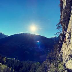
Ferrata de Tière is a K4 via ferrata in Massif de la Giffre.
Image: Source: ferrataguide:372
Difficulty
K4
Very difficult via ferrata
Current status
Currently reported open
Checked 17 h ago
Total time
2 h 30 min
Approach + via ferrata + descent
Last lift down
Check Massif de la Giffre timetable
Segment timings and vertical stats from the current VFOS dataset.
Start up a rock step onto a strip that leads to a vertical section which was named the Mur de l’Aragne blantze, or "wall of the white spider"; don't worry, the passages of the de Tière via ferrata, though named after it, are not so deadly as the real 'white spider' on the Eiger North-face. The first suspension bridge crosses the Tière-stream (during times of high water expect a good rinse). Then head upwards through a forest and onto the second, longer suspension bridge, the "Passerelle des Grandes Casca". This is followed by a slight descent along the Bären-band (bear ledge). Then comes the crossing through the Falaise de Tière, with excellent traverses and a slightly overhanging rock section, the "Surplomb de la Râtoulive". To finish, there is the final vertical climb (the "Lou Rathé à l’Ano" section) to the exit of the route (about 1190 m.) in the forest.
No escape point details are recorded yet.
Zoomable topographic map showing available approach, via ferrata, descent, start, finish, and parking geometry. The Download GPX link near the route map heading provides the same route geometry as a file.
Plan around the trailhead, parking, and public transport links.
Last lift down
Check operator
VFOS editorial ratings on a 1-5 scale.
Variety
How much the route changes in movement and terrain.
TBC TBC
Complexity
Route-finding and technical problem-solving beyond pure grade.
TBC TBC
Beauty
Scenery, setting, and overall aesthetic quality.
TBC TBC
Exposure
Airiness and exposure independent of technical difficulty.
TBC TBC
Sustained effort
How continuous or relentless the physical effort feels.
TBC TBC
No crux tags are recorded yet.
Ferrata de Tière is a K4 via ferrata in Massif de la Giffre.
Check current local information before setting off.
In Switzerland, call Rega on 1414 for mountain rescue. European emergency number: 112.
Cell coverage can be patchy in gorges, valleys, and behind ridges. Download route notes and tell someone your plan.
This route is flagged as exposed or high-grade; avoid thunderstorms, wet cables, and fast-changing alpine weather.
https://ferrataguide.com/ferrata/Ferrata_de_Ti%C3%A8re
Last scraped: 28 Jun 2026 · Facts harvested from public source pages; VFOS stores extracted facts and links back to source.
https://www.openstreetmap.org/relation/17980474
Last scraped: 4 Jun 2026 · OpenStreetMap object reference used for coordinate/source provenance; data available under ODbL.
https://www.sac-cas.ch/fr/cabanes-et-courses/portail-des-courses-du-cas/tiere-tiers-7803/via-ferrata/via-ferrata-de-tiere-736/
Last scraped: 28 Jun 2026 · Facts harvested from public source pages; VFOS stores extracted facts and links back to source.
https://www.openstreetmap.org/way/1014463566
Last scraped: 4 Jun 2026 · OpenStreetMap object reference used for coordinate/source provenance; data available under ODbL.
https://www.openstreetmap.org/way/1311586622
Last scraped: 4 Jun 2026 · OpenStreetMap object reference used for coordinate/source provenance; data available under ODbL.
https://www.openstreetmap.org/way/1311586623
Last scraped: 4 Jun 2026 · OpenStreetMap object reference used for coordinate/source provenance; data available under ODbL.
https://www.openstreetmap.org/way/1311586624
Last scraped: 4 Jun 2026 · OpenStreetMap object reference used for coordinate/source provenance; data available under ODbL.
https://www.openstreetmap.org/way/1311586625
Last scraped: 4 Jun 2026 · OpenStreetMap object reference used for coordinate/source provenance; data available under ODbL.
https://www.openstreetmap.org/way/1311586626
Last scraped: 4 Jun 2026 · OpenStreetMap object reference used for coordinate/source provenance; data available under ODbL.
No contested fields are currently flagged.
Weather