Difficulty
K5
Extremely difficult via ferrata
Berner Alpen
Ferrata des Rochers de Naye is a K5 via ferrata in Berner Alpen.
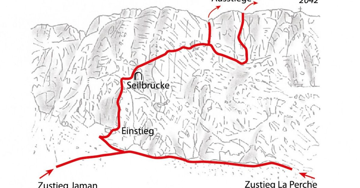
Image: Source: SAC-CAS route: Via ferrata Rochers de Naye
Difficulty
K5
Extremely difficult via ferrata
Current status
Currently reported open
Checked 17 h ago
Total time
2 h 5 min
Approach + via ferrata + descent
Last lift down
Check Berner Alpen timetable
Segment timings and vertical stats from the current VFOS dataset.
Blimey! Straight into a 50-meter-high, vertical to overhanging section (K5-) - the forearms get pumped immediately! Once you're sufficiently 'broken in' the steepness starts to decrease. A rope bridge leads into a cave (Gouffre de Niton, aka Grotto à Lemmy) - here you can benefit from short (or longer) break. The next bit requires courage and strength (K5-) before slackening off again (though arm strength is repeatedly needed on the following diagonal ramp which leads up to a grassy band, which leads then down and up to a junction. You may either finish through a vertical corner ("échappatoire", 40 m) - between the 1st of May and the 1st of July you must use this exit as the harder variation is closed due to breeding birds. Otherwise, if you're up for the challenge, descend along the grassy band, then climb up a slab, move diagonally to the left over another, exposed slab to a daunting overhang (K5 +). The end is reached at about 1990 meters.
No escape point details are recorded yet.
Zoomable topographic map showing available approach, via ferrata, descent, start, finish, and parking geometry. The Download GPX link near the route map heading provides the same route geometry as a file.
Plan around the trailhead, parking, and public transport links.
Last lift down
Check operator
VFOS editorial ratings on a 1-5 scale.
Variety
How much the route changes in movement and terrain.
TBC TBC
Complexity
Route-finding and technical problem-solving beyond pure grade.
TBC TBC
Beauty
Scenery, setting, and overall aesthetic quality.
TBC TBC
Exposure
Airiness and exposure independent of technical difficulty.
TBC TBC
Sustained effort
How continuous or relentless the physical effort feels.
TBC TBC
No crux tags are recorded yet.
Ferrata des Rochers de Naye is a K5 via ferrata in Berner Alpen.
Check current local information before setting off.
In Switzerland, call Rega on 1414 for mountain rescue. European emergency number: 112.
Cell coverage can be patchy in gorges, valleys, and behind ridges. Download route notes and tell someone your plan.
This route is flagged as exposed or high-grade; avoid thunderstorms, wet cables, and fast-changing alpine weather.
https://ferrataguide.com/ferrata/Ferrata_des_Rochers_de_Naye
Last scraped: 28 Jun 2026 · Facts harvested from public source pages; VFOS stores extracted facts and links back to source.
https://www.sac-cas.ch/fr/cabanes-et-courses/portail-des-courses-du-cas/rochers-de-naye-1283/via-ferrata/via-ferrata-rochers-de-naye-718/
Last scraped: 28 Jun 2026 · Facts harvested from public source pages; VFOS stores extracted facts and links back to source.
https://www.openstreetmap.org/way/1429739480
Last scraped: 4 Jun 2026 · OpenStreetMap object reference used for coordinate/source provenance; data available under ODbL.
https://www.openstreetmap.org/way/1434558903
Last scraped: 4 Jun 2026 · OpenStreetMap object reference used for coordinate/source provenance; data available under ODbL.
https://www.openstreetmap.org/way/816799884
Last scraped: 4 Jun 2026 · OpenStreetMap object reference used for coordinate/source provenance; data available under ODbL.
No contested fields are currently flagged.
Weather