Difficulty
K2
Moderate via ferrata
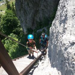
Glarner Alpen
Historischer Klettersteig Pinut is a K2 via ferrata in Glarner Alpen.
Image: Source: ferrataguide:394
Difficulty
K2
Moderate via ferrata
Current status
Currently reported open
Checked 17 h ago
Total time
4 h 15 min
Approach + via ferrata + descent
Last lift down
Check Glarner Alpen timetable
Segment timings and vertical stats from the current VFOS dataset.
The start 'kicks off' with multiple iron ladders leading up through the vertical rock. After a solidly anchored, but very exposed bridge, one turns into an apparently bricked up corner; On the left, a freestanding tower reaches into the sky. Ladders facilitate exit from the lower grotto and bring you to the entrance of a 20 metre long, natural tunnel. Watch out for the booby trap: there's a big hole in the floor, which is covered by a lying ladder, and offers a vertiginous downwards view. Through the (now permanently open) historic door you'll arrive back in the daylight; a ledge leads to the next series of ladders, which will bring you to the sparsely forested Pinutwiese (hanging meadows). A zigzag path brings you to a second cliff band and continuation of the ferrata (more cables and ladders), which in turn leads to the next grassy slope, known as Pardatsch. Finally a third, shorter cliff band is overcome, and the wide pastures of the Flimsersteins is won.
No escape point details are recorded yet.
Zoomable topographic map showing available approach, via ferrata, descent, start, finish, and parking geometry. The Download GPX link near the route map heading provides the same route geometry as a file.
Plan around the trailhead, parking, and public transport links.
Last lift down
Check operator
VFOS editorial ratings on a 1-5 scale.
Variety
How much the route changes in movement and terrain.
TBC TBC
Complexity
Route-finding and technical problem-solving beyond pure grade.
TBC TBC
Beauty
Scenery, setting, and overall aesthetic quality.
TBC TBC
Exposure
Airiness and exposure independent of technical difficulty.
TBC TBC
Sustained effort
How continuous or relentless the physical effort feels.
TBC TBC
No crux tags are recorded yet.
Historischer Klettersteig Pinut is a K2 via ferrata in Glarner Alpen.
Check current local information before setting off.
In Switzerland, call Rega on 1414 for mountain rescue. European emergency number: 112.
Cell coverage can be patchy in gorges, valleys, and behind ridges. Download route notes and tell someone your plan.
Avoid thunderstorms and wet rock. Via ferrata cables can become hazardous quickly in poor weather.
https://ferrataguide.com/ferrata/Historischer_Klettersteig_Pinut
Last scraped: 28 Jun 2026 · Facts harvested from public source pages; VFOS stores extracted facts and links back to source.
https://www.sac-cas.ch/de/huetten-und-touren/sac-tourenportal/flimser-stein-7092/klettersteig/klettersteig-pinut-708/
Last scraped: 28 Jun 2026 · Facts harvested from public source pages; VFOS stores extracted facts and links back to source.
No contested fields are currently flagged.
Weather