Difficulty
K4
Very difficult via ferrata
Valais Alps
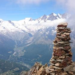
Panorama Klettersteig Jegihorn is a K4 via ferrata in Valais Alps.
Image: Source: ferrataguide:382
Difficulty
K4
Very difficult via ferrata
Current status
Currently reported open
Checked 17 h ago
Total time
6 h
Approach + via ferrata + descent
Last lift down
Check Valais Alps timetable
Segment timings and vertical stats from the current VFOS dataset.
Steel cables lead around a rock bluff and over staggered terrain to the base of a prominent groove. Continue the gradually steepening ascent (caution not to kick loose stones down!), then enter the main rock face. Climb the wall (cables, iron bars, ladders) nearly vertically and reach a shoulder. Cross another ladder to reach the subsidiary peak (3150 m). Now bear left onto a ledge and make a short descent to the start point of the large three-cable bridge. Cross the bridge to reach a steep climbing section (use the bolted-on stones for your feet!) which brings you back to the bypass. The bypass leads over exposed terrain past the western subsidiary summit and down into a saddle (3093 m) right below the Jegihorn. Continue, mostly just left of the ridge over to the final summit tower. On solid rock, climb up the progressively steeper and more exposed summit tower, with one section bringing you directly next to the edge of the ridge (Iron bolts). Eventually, the steepness eases and you can trundle over the last rocky steps to the spacious main summit (3206 m).
Descend the normal route to the footpath junction at P 2738. Continue on the path, then bear right and follow the Triftbach-stream down to Kreuzboden, or traverse over to the Weissmieshütte.
No escape point details are recorded yet.
Zoomable topographic map showing available approach, via ferrata, descent, start, finish, and parking geometry. The Download GPX link near the route map heading provides the same route geometry as a file.
Plan around the trailhead, parking, and public transport links.
Last lift down
Check operator
VFOS editorial ratings on a 1-5 scale.
Variety
How much the route changes in movement and terrain.
TBC TBC
Complexity
Route-finding and technical problem-solving beyond pure grade.
TBC TBC
Beauty
Scenery, setting, and overall aesthetic quality.
TBC TBC
Exposure
Airiness and exposure independent of technical difficulty.
TBC TBC
Sustained effort
How continuous or relentless the physical effort feels.
TBC TBC
No crux tags are recorded yet.
Panorama Klettersteig Jegihorn is a K4 via ferrata in Valais Alps.
Check current local information before setting off.
In Switzerland, call Rega on 1414 for mountain rescue. European emergency number: 112.
Cell coverage can be patchy in gorges, valleys, and behind ridges. Download route notes and tell someone your plan.
This route is flagged as exposed or high-grade; avoid thunderstorms, wet cables, and fast-changing alpine weather.
https://ferrataguide.com/ferrata/Jegihorn-Klettersteig
Last scraped: 28 Jun 2026 · Facts harvested from public source pages; VFOS stores extracted facts and links back to source.
https://www.sac-cas.ch/en/huts-and-tours/sac-route-portal/jegihorn-saas-grund-7799/via-ferrata/panorama-jegihorn-via-ferrata-728/
Last scraped: 28 Jun 2026 · Facts harvested from public source pages; VFOS stores extracted facts and links back to source.
No contested fields are currently flagged.
Weather