Difficulty
K4
Very difficult via ferrata
Location TBC
Klettersteig Leukerbad Daubenhorn (short variant) is a K4 via ferrata in Location TBC.
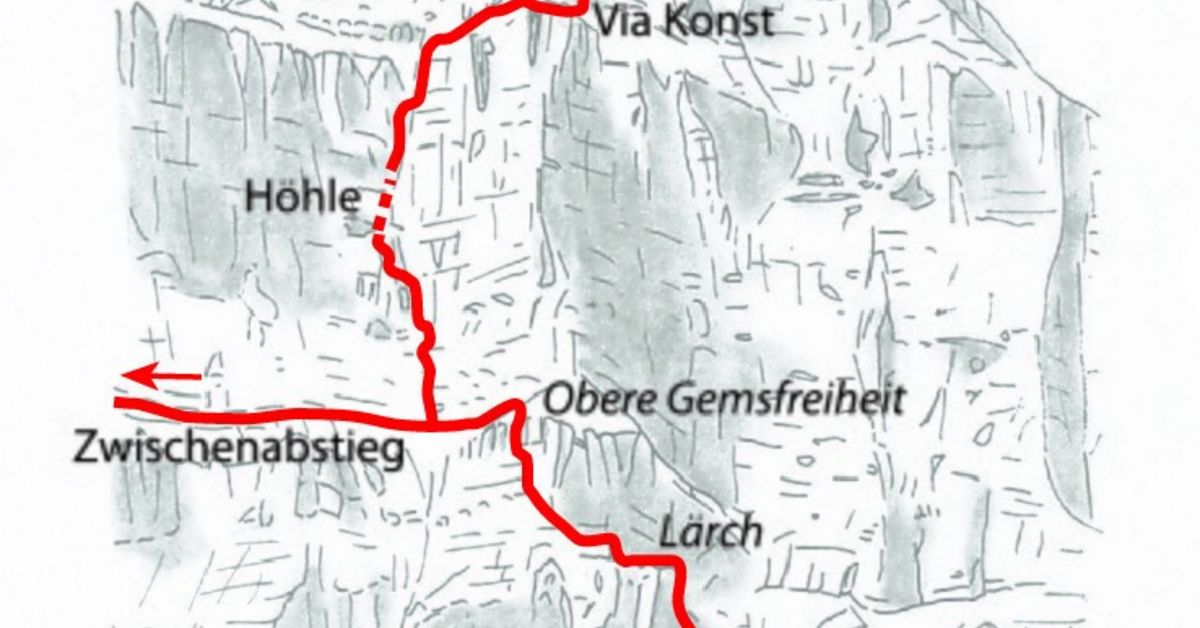
Image: Source: SAC-CAS route: Leukerbad / Daubenhorn via ferrata (small version)
Difficulty
K4
Very difficult via ferrata
Current status
No reliable current status yet
Checked 17 h ago
Total time
TBC
Approach + via ferrata + descent
Last lift down
Check Location TBC timetable
Segment timings and vertical stats from the current VFOS dataset.
From the cable car station (2346 m) down to Gemmipass; from here descend left on an old path down to the Lower Schmitte, where a large information board stands (about 2060 m, 20 min.).
Follow the clear trail across the meadow to the foot of the rock, then cross a wild rock basin to the first steel cables. Follow some narrow bands around the "nose" with thrilling views of the first steep section. Here the route shows its class: in very steep terrain, up close and personal, work your way up to the Lerch (about 2190 m), a grassy pulpit in the wall. Two short, but airy traverses, with some pull-ups in between, and you'll be in front of the first large ladder sequence: a total of 76 metres high. These spectacular ladders make for a real adrenaline rush; leading above the large Swiss Cross (visible from Leukerbad) to a striking shoulder on the Upper Gemsfreiheit (2345 m, 2 hrs. 20 min.). Now head left beneath the cliffs over to where the 'Small' and 'Large' ferrata split.
Follow the safety cable on a long, promising traverse to the sloping meadow of Mieläs (about 2350 m), then in zigzag, evading various rock steps (some cables), down into the grassy basin of Tysche (1832 m). Continue downhill, over the Pischürgraben to the huts of Fiess, then follow the Geissenweg back to Leukerbad (5½ hours from Gemmipass).
No escape point details are recorded yet.
Zoomable topographic map showing available approach, via ferrata, descent, start, finish, and parking geometry. The Download GPX link near the route map heading provides the same route geometry as a file.
Plan around the trailhead, parking, and public transport links.
Last lift down
Check operator
Transport nodes are not linked yet. Use the start-point navigation and verify access locally.
VFOS editorial ratings on a 1-5 scale.
Variety
How much the route changes in movement and terrain.
TBC TBC
Complexity
Route-finding and technical problem-solving beyond pure grade.
TBC TBC
Beauty
Scenery, setting, and overall aesthetic quality.
TBC TBC
Exposure
Airiness and exposure independent of technical difficulty.
TBC TBC
Sustained effort
How continuous or relentless the physical effort feels.
TBC TBC
No crux tags are recorded yet.
Klettersteig Leukerbad Daubenhorn (short variant) is a K4 via ferrata in Location TBC.
Check current local information before setting off.
In Switzerland, call Rega on 1414 for mountain rescue. European emergency number: 112.
Cell coverage can be patchy in gorges, valleys, and behind ridges. Download route notes and tell someone your plan.
This route is flagged as exposed or high-grade; avoid thunderstorms, wet cables, and fast-changing alpine weather.
https://www.viaferrata-leukerbad.ch/klettersteig-daubenhorn
Last scraped: 4 Jun 2026 · Source used for attribution and factual cross-checking; canonical VFOS text is paraphrased separately.
https://www.sac-cas.ch/en/huts-and-tours/sac-route-portal/daubenhorn-486/via-ferrata/leukerbad-daubenhorn-via-ferrata-small-version-707/
Last scraped: 5 Jun 2026 · SAC-CAS route portal source used for route geometry and factual cross-checking; VFOS links back for attribution.
https://www.openstreetmap.org/way/232392511
Last scraped: 4 Jun 2026 · OpenStreetMap object reference used for coordinate/source provenance; data available under ODbL.
No contested fields are currently flagged.
Weather