Difficulty
K4
Very difficult via ferrata
Valais Alps
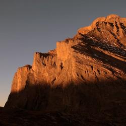
Klettersteig Leukerbad Daubenhorn (long variant) is a K4 via ferrata in Valais Alps.
Image: Source: ferrataguide:377
Difficulty
K4
Very difficult via ferrata
Current status
Currently reported open
Checked 17 h ago
Total time
8 h 30 min
Approach + via ferrata + descent
Last lift down
Check Valais Alps timetable
Segment timings and vertical stats from the current VFOS dataset.
From the cable car station (2346 m) head down to Gemmipass, then turn left (SE) following the old path down to the Lower Schmitte (a grassy terrace), where a large information board stands (about 2060 m, 20 min).
High in the wild canyon above the start, a ladder blinks in the morning sun. Steel cables and iron bars help you to overcome the steep rock. After climbing up a vertical corner (rockfall hazard, waterfall and very strenuous) comes the entrance of an almost 100 metre shaft (2575 m), offering a very special experience of light and shadow. There are two route options to choose from: an easier (but usually wetter) one, which is quite difficult, but has two suspension bridges and the second overhanging and spectacular detour into the "Underworld" which is followed by an extremely exhausting climb, except for a short horizontal band. After this, the steepness decreases slightly; at the old bivouac site (a grotto ca. 2720 m), the "Ferratisti" may then (possibly with a slightly shaky hand) register in the route book. For the intrepid traveller, there is now an absolute blast: the "Via Konst" - short, crisp and very airy. It leads through a cave into the slightly overhanging wall, from which - with a few hundred meters of air under your butt - you climb over iron rungs into "safer" terrain - wow! The normal route runs from the bivouac place first over scree, then along the rocky ridge to the summit rocks of the Daubenhorn. After a longer traverse comes the last ladder: 30 meters high, slightly overhanging, which brings you out onto the ridge and shortly to the summit of the Daubenhorn (2941 m, 5¾ hrs.).
Shortly down to the crevasse-free Daubenhorn glacier, which you cross to the northwest. Along a clearly defined, white-blue-white marked track over screes downhill to Lämmerenboden, then right back to the Gemmi Pass (2346 m, 8 hours).
No escape point details are recorded yet.
Zoomable topographic map showing available approach, via ferrata, descent, start, finish, and parking geometry. The Download GPX link near the route map heading provides the same route geometry as a file.
Plan around the trailhead, parking, and public transport links.
Last lift down
Check operator
VFOS editorial ratings on a 1-5 scale.
Variety
How much the route changes in movement and terrain.
TBC TBC
Complexity
Route-finding and technical problem-solving beyond pure grade.
TBC TBC
Beauty
Scenery, setting, and overall aesthetic quality.
TBC TBC
Exposure
Airiness and exposure independent of technical difficulty.
TBC TBC
Sustained effort
How continuous or relentless the physical effort feels.
TBC TBC
No crux tags are recorded yet.
Klettersteig Leukerbad Daubenhorn (long variant) is a K4 via ferrata in Valais Alps.
Check current local information before setting off.
In Switzerland, call Rega on 1414 for mountain rescue. European emergency number: 112.
Cell coverage can be patchy in gorges, valleys, and behind ridges. Download route notes and tell someone your plan.
This route is flagged as exposed or high-grade; avoid thunderstorms, wet cables, and fast-changing alpine weather.
https://ferrataguide.com/ferrata/Klettersteig_Leukerbad_Daubenhorn_%28variant_E%29
Last scraped: 4 Jun 2026 · Source used for attribution and factual cross-checking; canonical VFOS text is paraphrased separately.
https://www.sac-cas.ch/en/huts-and-tours/sac-route-portal/daubenhorn-486/via-ferrata/leukerbad-daubenhorn-via-ferrata-long-version-667/
Last scraped: 5 Jun 2026 · SAC-CAS route portal source used for route geometry and factual cross-checking; VFOS links back for attribution.
No contested fields are currently flagged.
Weather