Difficulty
K3
Difficult via ferrata
Location TBC
Klettersteig Piz Trovat I is a K3 via ferrata in Location TBC.
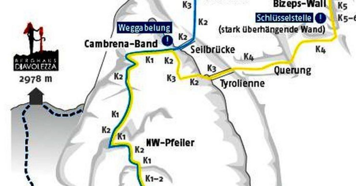
Image: Source: SAC-CAS route: Piz Trovat via ferrata
Difficulty
K3
Difficult via ferrata
Current status
Currently reported open
Checked 17 h ago
Total time
TBC
Approach + via ferrata + descent
Last lift down
Check Location TBC timetable
Segment timings and vertical stats from the current VFOS dataset.
After steepish start, you come again into broken ground. Then you climb a vertical ladder. Various iron leads on, first almost in the fall line, then rightwards along a ledge, always with a clear view of the most beautiful mountain scenery of the Upper Engadine. Along another rock band "Piz Trovat II" branches off to the right. A short descent leads to a suspension bridge over a deep couloir, then comes the key passage, the headwall: almost vertical, but plastered with metal aids. You may still get a sweat up, but don't be afraid; this is controlled adventure. A taunting tap with a sign leaves no doubt where the nearest (beer) filling station is. Its still a long way off. More climbing, almost consistently on iron rungs, with little rock contact will have to be mastered. Finally, the steep terrain eases off and, a little to the left of the summit, you can climb out onto the scree bedecked roof of Piz Trovat.
No escape point details are recorded yet.
Zoomable topographic map showing available approach, via ferrata, descent, start, finish, and parking geometry. The Download GPX link near the route map heading provides the same route geometry as a file.
Plan around the trailhead, parking, and public transport links.
Last lift down
Check operator
Transport nodes are not linked yet. Use the start-point navigation and verify access locally.
VFOS editorial ratings on a 1-5 scale.
Variety
How much the route changes in movement and terrain.
TBC TBC
Complexity
Route-finding and technical problem-solving beyond pure grade.
TBC TBC
Beauty
Scenery, setting, and overall aesthetic quality.
TBC TBC
Exposure
Airiness and exposure independent of technical difficulty.
TBC TBC
Sustained effort
How continuous or relentless the physical effort feels.
TBC TBC
No crux tags are recorded yet.
Klettersteig Piz Trovat I is a K3 via ferrata in Location TBC.
Check current local information before setting off.
In Switzerland, call Rega on 1414 for mountain rescue. European emergency number: 112.
Cell coverage can be patchy in gorges, valleys, and behind ridges. Download route notes and tell someone your plan.
Avoid thunderstorms and wet rock. Via ferrata cables can become hazardous quickly in poor weather.
https://www.openstreetmap.org/relation/6503413
Last scraped: 4 Jun 2026 · OpenStreetMap object reference used for coordinate/source provenance; data available under ODbL.
https://www.sac-cas.ch/en/huts-and-tours/sac-route-portal/piz-trovat-2035/via-ferrata/piz-trovat-via-ferrata-678/
Last scraped: 5 Jun 2026 · SAC-CAS route portal source used for route geometry and factual cross-checking; VFOS links back for attribution.
No contested fields are currently flagged.
Weather