Difficulty
K2
Moderate via ferrata
Location TBC
Klettersteig Sunnighorn Simmeflueh is a K2 via ferrata in Location TBC.
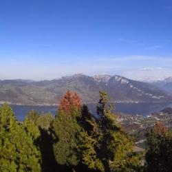
Image: Source: ferrataguide:1985
Difficulty
K2
Moderate via ferrata
Current status
Currently reported open
Checked 17 h ago
Total time
2 h 40 min
Approach + via ferrata + descent
Last lift down
Check Location TBC timetable
Segment timings and vertical stats from the current VFOS dataset.
No escape point details are recorded yet.
Zoomable topographic map showing available approach, via ferrata, descent, start, finish, and parking geometry. The Download GPX link near the route map heading provides the same route geometry as a file.
Plan around the trailhead, parking, and public transport links.
Last lift down
Check operator
VFOS editorial ratings on a 1-5 scale.
Variety
How much the route changes in movement and terrain.
TBC TBC
Complexity
Route-finding and technical problem-solving beyond pure grade.
TBC TBC
Beauty
Scenery, setting, and overall aesthetic quality.
TBC TBC
Exposure
Airiness and exposure independent of technical difficulty.
TBC TBC
Sustained effort
How continuous or relentless the physical effort feels.
TBC TBC
No crux tags are recorded yet.
Klettersteig Sunnighorn Simmeflueh is a K2 via ferrata in Location TBC.
Check current local information before setting off.
In Switzerland, call Rega on 1414 for mountain rescue. European emergency number: 112.
Cell coverage can be patchy in gorges, valleys, and behind ridges. Download route notes and tell someone your plan.
Avoid thunderstorms and wet rock. Via ferrata cables can become hazardous quickly in poor weather.
https://ferrataguide.com/ferrata/Klettersteig_Sunnighorn
Last scraped: 4 Jun 2026 · Source used for attribution and factual cross-checking; canonical VFOS text is paraphrased separately.
No contested fields are currently flagged.
Weather