Difficulty
K3-K4
Very difficult via ferrata
Walliser Alpen
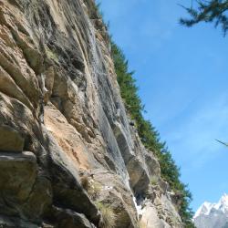
Mammut Schweifinen Klettersteig Zermatt is a K3-K4 via ferrata in Walliser Alpen.
Image: Source: ferrataguide:497
Difficulty
K3-K4
Very difficult via ferrata
Current status
Currently reported open
Checked 17 h ago
Total time
4 h 30 min
Approach + via ferrata + descent
Last lift down
Check Walliser Alpen timetable
Segment timings and vertical stats from the current VFOS dataset.
Route A climbs through rocky-earthy terrain, bearing left. From an intersection, one dead-end trail leads to an abseil point (abseiling is only recommended with a mountain guide!) from which you can descend a beautiful, exposed drop high over the Triftbach stream. Shortly after, you'll be standing in front of the so-called "Beresina-hut im Pudel" (1920 m on the map). From the intersection, route B continues up an old, steep stone staircase. You can also choose this branch of route B to reach route C above the vertical Turuwang (with the difficult section of route B). Most will descend via route A to a forested ledge, until route B branches off to the left; the old path to the Beresina hut used to lead along this ledge (it is still indicated on the map from 1972 for example). Before reaching the intersection, route A leads off further down, to the bottom of the wall. Now upwards to route B over the smooth, vertical and partially overhanging rock wall, at the very top via a metal wire ladder, the crux of the entire tour. Afterwards descending in mostly vertical terrain with a very exposed traverse on 'slightly wobbly' wooden elements. At last, ascend and exit from the Turuwang (wall) into the Turu-forest, where route B and C split (about 1890 m). From here you could simply cross the forest and return to the Beresina-hut. Yet, continuing on route C is rather more beautiful and exciting. Start with a diagonal descent, crossing some gullies, before making a steep climb which requires the use of your forearms. Via the ladder at the top you will pass a wooden Madonna, that was placed there by the routes' first-ascensionist, Walter Perren, together with the wood carver Hugo Lehner in 1984; even rusting pegs are still visible. Climb out onto a shoulder, then you traverse back down once more, passing a waterfall (at least during early summer) - be very careful here due to the slippery and sloping terrain. Ascend once again, via a partly vertical section. Pass a fake water tap - when the sun is burning you will be even thirstier. After scrabbling up a wire ladder, the signing of the guest book will bring joy and pride; a final easier ladder provides no more difficulties. The via ferrata finishes at about 2110 metres. Cross the grassy slopes of Schweifinen to reach the hiking path at 2180 metres.
No escape point details are recorded yet.
Zoomable topographic map showing available approach, via ferrata, descent, start, finish, and parking geometry. The Download GPX link near the route map heading provides the same route geometry as a file.
Plan around the trailhead, parking, and public transport links.
Last lift down
Check operator
VFOS editorial ratings on a 1-5 scale.
Variety
How much the route changes in movement and terrain.
TBC TBC
Complexity
Route-finding and technical problem-solving beyond pure grade.
TBC TBC
Beauty
Scenery, setting, and overall aesthetic quality.
TBC TBC
Exposure
Airiness and exposure independent of technical difficulty.
TBC TBC
Sustained effort
How continuous or relentless the physical effort feels.
TBC TBC
No crux tags are recorded yet.
Mammut Schweifinen Klettersteig Zermatt is a K3-K4 via ferrata in Walliser Alpen.
Check current local information before setting off.
In Switzerland, call Rega on 1414 for mountain rescue. European emergency number: 112.
Cell coverage can be patchy in gorges, valleys, and behind ridges. Download route notes and tell someone your plan.
This route is flagged as exposed or high-grade; avoid thunderstorms, wet cables, and fast-changing alpine weather.
https://ferrataguide.com/ferrata/Mammut_Schweifinen_Klettersteig_Zermatt
Last scraped: 28 Jun 2026 · Facts harvested from public source pages; VFOS stores extracted facts and links back to source.
https://www.sac-cas.ch/de/huetten-und-touren/sac-tourenportal/schweifinen-7800/klettersteig/klettersteig-zermatt-schweifinen-route-c-731/
Last scraped: 28 Jun 2026 · Facts harvested from public source pages; VFOS stores extracted facts and links back to source.
No contested fields are currently flagged.
Weather