Difficulty
K3
Difficult via ferrata
Walliser-Alpen
Mittaghorn-Klettersteig is a K3 via ferrata in Walliser-Alpen.
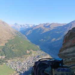
Image: Source: ferrataguide:384
Difficulty
K3
Difficult via ferrata
Current status
Currently reported open
Checked 17 h ago
Total time
5 h 45 min
Approach + via ferrata + descent
Last lift down
Check Walliser-Alpen timetable
Segment timings and vertical stats from the current VFOS dataset.
Short passages secured with steel cables alternate with longer walking sections. Only after a fat cairn the terrain becomes steeper, and you go from the odd secured section to full via ferrata. A short vertical step (iron steps) proves to be the first aptitude test for beginners; A little further on is a very exposed passage high above the Karboden (iron bar). Here your immunity to vertigo is tested. After a easier ridge section follows a steep slab. The finale involves some airy gymnastics utilising 21 iron rungs and a good dozen pins - with a view of the Fee Glacier and its four-thousander surrounds. The summit of Mittaghorn (3,143 m, 2¾ hours) offers a 360-degree panorama of the mountains and glaciers of the Saas Valley; and beyond the Rhone Valley, the shapely rock pyramid of the Bietschhorn. A further eye catcher to the south is the massive Mattmark reservoir.
No escape point details are recorded yet.
Zoomable topographic map showing available approach, via ferrata, descent, start, finish, and parking geometry. The Download GPX link near the route map heading provides the same route geometry as a file.
Plan around the trailhead, parking, and public transport links.
Last lift down
Check operator
VFOS editorial ratings on a 1-5 scale.
Variety
How much the route changes in movement and terrain.
TBC TBC
Complexity
Route-finding and technical problem-solving beyond pure grade.
TBC TBC
Beauty
Scenery, setting, and overall aesthetic quality.
TBC TBC
Exposure
Airiness and exposure independent of technical difficulty.
TBC TBC
Sustained effort
How continuous or relentless the physical effort feels.
TBC TBC
No crux tags are recorded yet.
Mittaghorn-Klettersteig is a K3 via ferrata in Walliser-Alpen.
Check current local information before setting off.
In Switzerland, call Rega on 1414 for mountain rescue. European emergency number: 112.
Cell coverage can be patchy in gorges, valleys, and behind ridges. Download route notes and tell someone your plan.
Avoid thunderstorms and wet rock. Via ferrata cables can become hazardous quickly in poor weather.
https://ferrataguide.com/ferrata/Mittaghorn-Klettersteig
Last scraped: 28 Jun 2026 · Facts harvested from public source pages; VFOS stores extracted facts and links back to source.
https://www.sac-cas.ch/en/huts-and-tours/sac-route-portal/mittaghorn-saas-fee-vs-1179/via-ferrata/mittaghorn-via-ferrata-732/
Last scraped: 28 Jun 2026 · Facts harvested from public source pages; VFOS stores extracted facts and links back to source.
No contested fields are currently flagged.
Weather