Difficulty
K3
Difficult via ferrata
Mürren, BE
A car-free Bernese Oberland traverse from Mürren toward Gimmelwald, seeded to prove public-transport-friendly route pages and map pins.
Image: Source: website
Difficulty
K3
Difficult via ferrata
Current status
Currently reported open
Checked 17 h ago
Total time
3 h 30 min
Approach + via ferrata + descent
Last lift down
Check Schilthornbahn / Mürren access timetable
Segment timings and vertical stats from the current VFOS dataset.
Brown signposts. Goes through a short tunnel beneath the tennis courts.
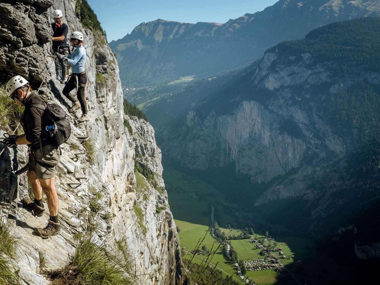
Through the unlit (and not signposted) tunnel to the south of the tennis courts (overview panel), then along the east side of the tennis court wall. From there descend and traverse, alternating between sections of rock and others of earth. The exposure slowly increases, and soon the first key point is reached: a passage about 600 metres vertically above the Lauterbrunnen Valley with its cable car station and parking lot — here is nothing but iron bars and a lot of air under the soles… And on it goes, sometimes on the cliff face itself and sometimes in the forest, all the way along the Mürrenfluh. A short, vertical ladder provides variety, as does the rather wobbly three-cable bridge over the Mürrenbach. At the same place is a 60-meter-long Tyrolienne, which can only be done in the company of mountain guides (“closed” sign, so choose the right branch at the junction). Before and after the Sinterbach are several passages with more ladders, which are partly vertical; the exposure, however, is small. Another short three-cable bridge over a canyon provides for a further variety. At about 1300 metres you have reached the lowest point of the via ferrata. And soon the finale comes: an 80-meter-long suspension bridge, which is very shaky and has no continuous tensioned cable handrail that one can hold on to. The safety cable available, is indeed quite movable and fixed only on every fourth suspension device. However, the suspension bridge can also be avoided, by turning right and moving up onto the normal footpath between Mürren and Gimmelwald. After the suspension bridge, the via ferrata is over and only the short ascent to the Gimmelwald cable car station is missing.
Short and straightforward.
No escape point details are recorded yet.
Zoomable topographic map showing available approach, via ferrata, descent, start, finish, and parking geometry. The Download GPX link near the route map heading provides the same route geometry as a file.
Plan around the trailhead, parking, and public transport links.
Last lift down
Check operator
VFOS editorial ratings on a 1-5 scale.
Variety
How much the route changes in movement and terrain.
Very high 5/5
Complexity
Route-finding and technical problem-solving beyond pure grade.
Moderate 3/5
Beauty
Scenery, setting, and overall aesthetic quality.
Very high 5/5
Exposure
Airiness and exposure independent of technical difficulty.
Very high 5/5
Sustained effort
How continuous or relentless the physical effort feels.
Moderate 3/5
No crux tags are recorded yet.
A car-free Bernese Oberland traverse from Mürren toward Gimmelwald, seeded to prove public-transport-friendly route pages and map pins.
Check current local information before setting off.
In Switzerland, call Rega on 1414 for mountain rescue. European emergency number: 112.
Cell coverage can be patchy in gorges, valleys, and behind ridges. Download route notes and tell someone your plan.
This route is flagged as exposed or high-grade; avoid thunderstorms, wet cables, and fast-changing alpine weather.
https://muerren.swiss/en/destination/about-murren/via-ferrata-murren.html
Last scraped: 30 May 2026 · Source used for attribution and factual cross-checking; VFOS stores only short, paraphrased seed notes.
https://klettersteig-muerren.ch/
Last scraped: 4 Jun 2026 · Source used for attribution and factual cross-checking; canonical VFOS text is paraphrased separately.
https://www.openstreetmap.org/relation/6680187
Last scraped: 30 May 2026 · OpenStreetMap object reference used for seed coordinate provenance; data available under ODbL.
https://www.sac-cas.ch/en/huts-and-tours/sac-route-portal/murrenbachfall-8215/via-ferrata/via-ferrata-murren-1846/
Last scraped: 5 Jun 2026 · SAC-CAS route portal source used for route geometry and factual cross-checking; VFOS links back for attribution.
No contested fields are currently flagged.
Weather