Difficulty
K2
Moderate via ferrata
Location TBC
Route B is a K2 via ferrata in Location TBC.
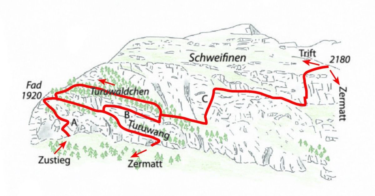
Image: Source: SAC-CAS route: Zermatt-Schweifinen Via ferrata Route B
Difficulty
K2
Moderate via ferrata
Current status
Currently reported open
Checked 17 h ago
Total time
TBC
Approach + via ferrata + descent
Last lift down
Check Location TBC timetable
Segment timings and vertical stats from the current VFOS dataset.
Route A climbs through rocky-earthy terrain, bearing left. From an intersection, one dead-end trail leads to an abseil point (abseiling is only recommended with a mountain guide!) from which you can descend a beautiful, exposed drop high over the Triftbach stream. Shortly after, you'll be standing in front of the so-called "Beresina-hut im Pudel" (1920 m on the map). From the intersection, route B continues up an old, steep stone staircase. You can also choose this branch of route B to reach route C above the vertical Turuwang (with the difficult section of route B). Most will descend via route A to a forested ledge, until route B branches off to the left; the old path to the Beresina hut used to lead along this ledge (it is still indicated on the map from 1972 for example). Before reaching the intersection, route A leads off further down, to the bottom of the wall. Now upwards to route B over the smooth, vertical and partially overhanging rock wall, at the very top via a metal wire ladder, the crux of the entire tour. Afterwards descending in mostly vertical terrain with a very exposed traverse on 'slightly wobbly' wooden elements. At last, ascend and exit from the Turuwang (wall) into the Turu-forest, where route B and C split (about 1890 m). From here you could simply cross the forest and return to the Beresina-hut via a step. Yet, continuing on route C is rather more beautiful and exerting.
No escape point details are recorded yet.
Zoomable topographic map showing available approach, via ferrata, descent, start, finish, and parking geometry. The Download GPX link near the route map heading provides the same route geometry as a file.
Plan around the trailhead, parking, and public transport links.
Last lift down
Check operator
Transport nodes are not linked yet. Use the start-point navigation and verify access locally.
VFOS editorial ratings on a 1-5 scale.
Variety
How much the route changes in movement and terrain.
TBC TBC
Complexity
Route-finding and technical problem-solving beyond pure grade.
TBC TBC
Beauty
Scenery, setting, and overall aesthetic quality.
TBC TBC
Exposure
Airiness and exposure independent of technical difficulty.
TBC TBC
Sustained effort
How continuous or relentless the physical effort feels.
TBC TBC
No crux tags are recorded yet.
Route B is a K2 via ferrata in Location TBC.
Check current local information before setting off.
In Switzerland, call Rega on 1414 for mountain rescue. European emergency number: 112.
Cell coverage can be patchy in gorges, valleys, and behind ridges. Download route notes and tell someone your plan.
Avoid thunderstorms and wet rock. Via ferrata cables can become hazardous quickly in poor weather.
https://www.sac-cas.ch/en/huts-and-tours/sac-route-portal/schweifinen-7800/via-ferrata/zermatt-schweifinen-via-ferrata-route-b-730/
Last scraped: 5 Jun 2026 · SAC-CAS route portal source used for route geometry and factual cross-checking; VFOS links back for attribution.
https://www.openstreetmap.org/way/1294080592
Last scraped: 4 Jun 2026 · OpenStreetMap object reference used for coordinate/source provenance; data available under ODbL.
No contested fields are currently flagged.
Weather