Difficulty
K4-K5
Extremely difficult via ferrata
Rätikon
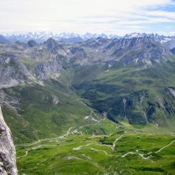
Sulzfluh Klettersteig is a K4-K5 via ferrata in Rätikon.
Image: Source: ferrataguide:168
Difficulty
K4-K5
Extremely difficult via ferrata
Current status
Currently reported open
Checked 17 h ago
Total time
7 h
Approach + via ferrata + descent
Last lift down
Check Rätikon timetable
Segment timings and vertical stats from the current VFOS dataset.
Steel cables lead over oblique slabs to the vertical starting ladder, iron rungs then help through a chimney. The easy "Obelixquergang" is followed by a steep rock step, made easy with more iron rungs; more ledges and steps follow until the so-called 'ramp'. The ramp is climbed (good natural steps and handles) to reach a grass band. Head shortly left, then practice your pull ups on a 15 meter high vertical wall. Behind the "Geissrücken" a wooden bench invites you to take a breather. One should take advantage of the opportunity, as the difficulties still increase slightly higher on the wall. After a longer easy traverse the next challenge for strength and psyche follows: a power sapping 30 meter high wall. This is followed by the "Panoramica", which lives up to its name. More iron steps lead up a slab to another, more difficult traverse, where either good technique or brute strength is required. The next highlight of the route is the "Deichmannsteg", a three-cable bridge. If you manage this small balancing act, the route book awaits. Then there is one last challenge, the "Wailing Wall": 40 meters high, slightly overhanging at the beginning - that will make your forearms burn. The rest is merely an encore: a small iron bridge, a last easy step, and then you stand next to the summit cross and enjoy the great panorama of Sulzfluh (2817 m, 4¾ hrs.). Please feel free to make a small donation towards the ferrata's upkeep. A big Thank you! in advance.
No escape point details are recorded yet.
Zoomable topographic map showing available approach, via ferrata, descent, start, finish, and parking geometry. The Download GPX link near the route map heading provides the same route geometry as a file.
Plan around the trailhead, parking, and public transport links.
Last lift down
Check operator
VFOS editorial ratings on a 1-5 scale.
Variety
How much the route changes in movement and terrain.
TBC TBC
Complexity
Route-finding and technical problem-solving beyond pure grade.
TBC TBC
Beauty
Scenery, setting, and overall aesthetic quality.
TBC TBC
Exposure
Airiness and exposure independent of technical difficulty.
TBC TBC
Sustained effort
How continuous or relentless the physical effort feels.
TBC TBC
No crux tags are recorded yet.
Sulzfluh Klettersteig is a K4-K5 via ferrata in Rätikon.
Check current local information before setting off.
In Switzerland, call Rega on 1414 for mountain rescue. European emergency number: 112.
Cell coverage can be patchy in gorges, valleys, and behind ridges. Download route notes and tell someone your plan.
This route is flagged as exposed or high-grade; avoid thunderstorms, wet cables, and fast-changing alpine weather.
https://ferrataguide.com/ferrata/Sulzfluh_Klettersteig
Last scraped: 28 Jun 2026 · Facts harvested from public source pages; VFOS stores extracted facts and links back to source.
https://www.openstreetmap.org/relation/6332638
Last scraped: 4 Jun 2026 · OpenStreetMap object reference used for coordinate/source provenance; data available under ODbL.
https://www.sac-cas.ch/en/huts-and-tours/sac-route-portal/sulzfluh-1911/via-ferrata/sulzfluh-via-ferrata-675/
Last scraped: 28 Jun 2026 · Facts harvested from public source pages; VFOS stores extracted facts and links back to source.
https://www.openstreetmap.org/way/45348185
Last scraped: 4 Jun 2026 · OpenStreetMap object reference used for coordinate/source provenance; data available under ODbL.
https://www.openstreetmap.org/way/76351990
Last scraped: 4 Jun 2026 · OpenStreetMap object reference used for coordinate/source provenance; data available under ODbL.
https://www.openstreetmap.org/way/76351991
Last scraped: 4 Jun 2026 · OpenStreetMap object reference used for coordinate/source provenance; data available under ODbL.
No contested fields are currently flagged.
Weather