Difficulty
K4
Very difficult via ferrata
Berner Alpen
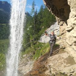
Via Ferrata de la Cascade is a K4 via ferrata in Berner Alpen.
Image: Source: ferrataguide:491
Difficulty
K4
Very difficult via ferrata
Current status
Currently reported open
Checked 17 h ago
Total time
2 h
Approach + via ferrata + descent
Last lift down
Check Berner Alpen timetable
Segment timings and vertical stats from the current VFOS dataset.
If you do not feel confident enough to tackle the first steep section, you can avoid it to the left. This ferrata jumps straight into vertical and overhanging sections followed by a three-cable bridge; the exit from this is quite tricky. Then you climb to the top of the rock face; here is where the easier version joins on. Now, for the time being, follow a grassy ledge across the wall, then continue the traverse on vertical ground under an eye-catching semicircular roof, up to reach a "hanging garden" with gnarled old spruce trees. Descend an airy ladder and into a groove. Here is an escape option. From here the ferrata become easier, continues, following various ledges up and down, traversing a long distance across the high rock face with numerous other sport climbing routes. A short bridge provides entertainment before a narrow corner gives you a squeeze. At its foot, the way ahead splits. Anyone feeling still fresh and confident can head for the Tyrolienne - if it is still installed - in the direction of the waterfall (if its there) and may whizz down its 80 m length! From the landing area, descend a small track to the main path. To avoid the Tyrolienne, head right of the stream through some steep, bushy terrain to meet the path (1460 m).
Either back to the Col du Pillon, or down to the town of Les Diablerets.
No escape point details are recorded yet.
Zoomable topographic map showing available approach, via ferrata, descent, start, finish, and parking geometry. The Download GPX link near the route map heading provides the same route geometry as a file.
Plan around the trailhead, parking, and public transport links.
Last lift down
Check operator
VFOS editorial ratings on a 1-5 scale.
Variety
How much the route changes in movement and terrain.
TBC TBC
Complexity
Route-finding and technical problem-solving beyond pure grade.
TBC TBC
Beauty
Scenery, setting, and overall aesthetic quality.
TBC TBC
Exposure
Airiness and exposure independent of technical difficulty.
TBC TBC
Sustained effort
How continuous or relentless the physical effort feels.
TBC TBC
No crux tags are recorded yet.
Via Ferrata de la Cascade is a K4 via ferrata in Berner Alpen.
Check current local information before setting off.
In Switzerland, call Rega on 1414 for mountain rescue. European emergency number: 112.
Cell coverage can be patchy in gorges, valleys, and behind ridges. Download route notes and tell someone your plan.
This route is flagged as exposed or high-grade; avoid thunderstorms, wet cables, and fast-changing alpine weather.
https://ferrataguide.com/ferrata/Via_Ferrata_de_la_Cascade
Last scraped: 4 Jun 2026 · Source used for attribution and factual cross-checking; canonical VFOS text is paraphrased separately.
https://www.sac-cas.ch/en/huts-and-tours/sac-route-portal/cascade-du-dar-7792/via-ferrata/via-ferrata-cascade-du-dar-713/
Last scraped: 5 Jun 2026 · SAC-CAS route portal source used for route geometry and factual cross-checking; VFOS links back for attribution.
No contested fields are currently flagged.
Weather