Difficulty
K4
Very difficult via ferrata
Location TBC
Via ferrata des Gentianes Androsace is a K4 via ferrata in Location TBC.
Image: Source: ferrataguide:2018
Difficulty
K4
Very difficult via ferrata
Current status
Currently reported open
Checked 17 h ago
Total time
2 h 15 min
Approach + via ferrata + descent
Last lift down
Check Location TBC timetable
Segment timings and vertical stats from the current VFOS dataset.
The descent leads to the saddle between the two peaks and then down an easier via ferrata between the "Androsace" and "Edelweiss" ferratas.
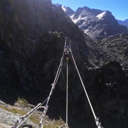
A three-cable bridge leads over a deep canyon to the start of the route proper. The following steep pillar has an intimidating overhang to surpass before it gets a little easier. A traverse to the right brings you to another bridge beneath a large roof. More overhanging and exposed climbing leads back left to the ridge. After a final difficult passage, easier climbing leads along the ridge to the summit, approx. 3035 m.
No escape point details are recorded yet.
Zoomable topographic map showing available approach, via ferrata, descent, start, finish, and parking geometry. The Download GPX link near the route map heading provides the same route geometry as a file.
Plan around the trailhead, parking, and public transport links.
Last lift down
Check operator
VFOS editorial ratings on a 1-5 scale.
Variety
How much the route changes in movement and terrain.
TBC TBC
Complexity
Route-finding and technical problem-solving beyond pure grade.
TBC TBC
Beauty
Scenery, setting, and overall aesthetic quality.
TBC TBC
Exposure
Airiness and exposure independent of technical difficulty.
TBC TBC
Sustained effort
How continuous or relentless the physical effort feels.
TBC TBC
No crux tags are recorded yet.
Via ferrata des Gentianes Androsace is a K4 via ferrata in Location TBC.
Check current local information before setting off.
In Switzerland, call Rega on 1414 for mountain rescue. European emergency number: 112.
Cell coverage can be patchy in gorges, valleys, and behind ridges. Download route notes and tell someone your plan.
This route is flagged as exposed or high-grade; avoid thunderstorms, wet cables, and fast-changing alpine weather.
https://ferrataguide.com/ferrata/Via_ferrata_des_Gentianes_Androsace
Last scraped: 4 Jun 2026 · Source used for attribution and factual cross-checking; canonical VFOS text is paraphrased separately.
https://www.openstreetmap.org/node/13011973955
Last scraped: 4 Jun 2026 · OpenStreetMap object reference used for coordinate/source provenance; data available under ODbL.
https://www.sac-cas.ch/en/huts-and-tours/sac-route-portal/pointe-de-cion-10702/via-ferrata/gentianes-androsace-via-ferrata-40506/
Last scraped: 5 Jun 2026 · SAC-CAS route portal source used for route geometry and factual cross-checking; VFOS links back for attribution.
No contested fields are currently flagged.
Weather